|
|
Antenna Structure Registration 1237797 |
 |
Registration Info | Registration Number: 1237797 |
| File Number: A0974535 |
| FAA Study: 2003-ANM-126-OE |
| FAA Issue Date: 02/18/2003 |
| Status: Constructed |
| Date Constructed: 01/01/2004 |
| FAA EMI: N |
| NEPA: N |
Structure Info
| Structure Type: TOWER |
| Structure Coordinates: 39-51-36.5 N 104-33-54.6 W (NAD 83) |
| Structure Coordinates: 39-51-36.6 N 104-33-52.7 W (Converted to NAD 27) |
| Structure Address: 35907 East 88th Avenue |
| Structure City: Watkins, CO |
| Structure County: Adams County |
| Painting & Lighting Info |
FAA Chapters: NONE |
Remarks: Removed expiration date from determination. Scenario 1./jjs/case#635066 |
| Elevation Info |
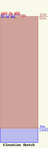
Site Elevation: 1647.1 meters (5404 ft) |
| Height of Structure: 20.4 meters (67 feet) |
| Overall Height Above Ground: 20.4 meters (67 feet) |
| Overall Height Above Mean Sea Level: 1667.5 meters (5471 feet) |
| Owner Info | Adcom911, Inc,
7321 Birch Street
Commerce City, CO 80022
(303) 227-7111
wleslie@adcom911.org |
| Contact Info | Adcom911, Inc,
7321 Birch Street
Commerce City, CO 80022
Walter Leslie
(303) 227-7111
wleslie@adcom911.org |
