|
|
Antenna Structure Registration 1238023 |
 |
Registration Info | Registration Number: 1238023 |
| File Number: A1381146 |
| FAA Study: 2003-ASO-662-OE |
| FAA Issue Date: 03/07/2003 |
| Status: Constructed |
| Date Constructed: 07/31/2003 |
| FAA EMI: N |
| NEPA: N |
Structure Info
| Structure Type: TOWER |
| Structure Coordinates: 32-51-38.0 N 83-36-55.2 W (NAD 83) |
| Structure Coordinates: 32-51-37.5 N 83-36-55.6 W (Converted to NAD 27) |
| Structure Address: 1314 Gray Highway |
| Structure City: Macon, GA |
| Structure County: Bibb County |
| Painting & Lighting Info |
FAA Chapters: NONE |
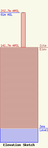
| Elevation Info |
Site Elevation: 141.7 meters (465 ft) |
| Height of Structure: 61 meters (200 feet) |
| Overall Height Above Ground: 61 meters (200 feet) |
| Overall Height Above Mean Sea Level: 202.7 meters (665 feet) |
| Owner Info | Pacific and Southern, LLC
8401 Greensboro Drive
McLean, VA 22102
(703) 873-6600
lawdept@tegna.com |
| Contact Info | TEGNA Inc.
8401 Greensboro Drive
McLean, VA 22102
Denise Branson
(703) 873-6606
dbranson@tegna.com |
