|
|
Antenna Structure Registration 1238605 |
 |
Registration Info | Registration Number: 1238605 |
| File Number: A0803723 |
| FAA Study: 2003-AWP-292-OE |
| FAA Issue Date: 03/15/2003 |
| Status: Cancelled |
| FAA EMI: N |
| NEPA: N |
Structure Info
| Structure Type: 6TA1 |
| Structure Coordinates: 34-7-9.2 N 118-4-54.7 W (NAD 83) |
| Structure Coordinates: 34-07-09.2 N 118-04-51.5 W (Converted to NAD 27) |
| Structure Address: 6544 North Vista Street |
| Structure City: San Gabriel, CA |
| Structure County: Los Angeles County |
| Painting & Lighting Info |
FAA Circular #: 70/7460-1K |
FAA Chapters: 4, 8, 12 |
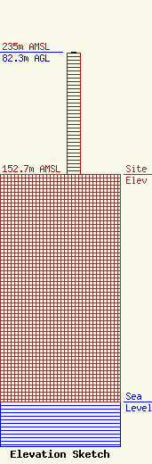
| Elevation Info |
Site Elevation: 152.7 meters (501 ft) |
| Height of Structure: 81.5 meters (267 feet) |
| Overall Height Above Ground: 82.3 meters (270 feet) |
| Overall Height Above Mean Sea Level: 235 meters (771 feet) |
| Owner Info | Multicultural Radio Broadcasting, Inc.
449 Broadway
New York, NY 10013
(212) 966-1059
jglogowski@aol.com |
| Contact Info | Radiotechniques Engineering Corp.
PO Box 367
Haddon Heights, NJ 08035
Edward Schober
(856) 546-8008
ted@radiotechniques.com |
