|
|
Antenna Structure Registration 1238973 |
 |
Registration Info | Registration Number: 1238973 |
| File Number: A1327515 |
| FAA Study: 2003-asw-1825-oe |
| FAA Issue Date: 05/20/2003 |
| Status: Constructed |
| Date Constructed: 12/31/2003 |
| NEPA: N |
Structure Info
|
| Structure Coordinates: 31-18-59.0 N 92-29-0.0 W (NAD 83) |
| Structure Coordinates: 31-18-58.3 N 92-28-59.5 W (Converted to NAD 27) |
| Structure Address: 1811 England Drive |
| Structure City: Alexandria, LA |
| Structure County: Rapides Parish |
| Painting & Lighting Info |
FAA Chapters: NONE |
Remarks: PRIOR STUDY 1980-ASW-2234-OE |
| Elevation Info |
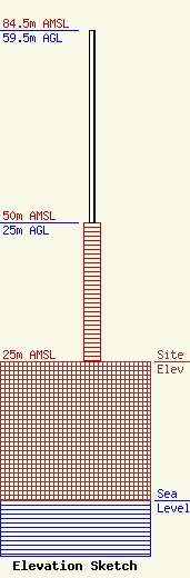
Site Elevation: 25 meters (82 ft) |
| Height of Structure: 25 meters (82 feet) |
| Overall Height Above Ground: 59.5 meters (195 feet) |
| Overall Height Above Mean Sea Level: 84.5 meters (277 feet) |
| Owner Info | Station RE Holdings LLC
3507
Jackson, MS 39207
(601) 360-9312
wcollums@aol.com |
| Contact Info | Baker & Hostetler LLP
1050 Connecticut Ave NW
Washington, DC 20036
Daniel Kirkpatrick
(202) 861-1758
dkirkpatrick@bakerlaw.com |
