|
|
Antenna Structure Registration 1239340 |
 |
Registration Info | Registration Number: 1239340 |
| File Number: A1139011 |
| FAA Study: 2015-ANE-1087-OE |
| FAA Issue Date: 08/31/2015 |
| Status: Constructed |
| Date Constructed: 09/20/2004 |
Structure Info
| Structure Type: LTOWER |
| Structure Coordinates: 44-29-21.0 N 69-39-4.8 W (NAD 83) |
| Structure Coordinates: 44-29-20.8 N 69-39-06.6 W (Converted to NAD 27) |
| Structure Address: End Of Cook Mountain Road |
| Structure City: Waterville, ME |
| Structure County: Kennebec County |
| Painting & Lighting Info |
FAA Chapters: NONE |
Remarks: PRIOR STUDY 2003-ANE-229-OE |
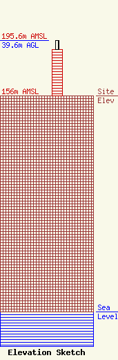
| Elevation Info |
Site Elevation: 156 meters (512 ft) |
| Height of Structure: 33.5 meters (110 feet) |
| Overall Height Above Ground: 39.6 meters (130 feet) |
| Overall Height Above Mean Sea Level: 195.6 meters (642 feet) |
| Owner Info | Maine Public Broadcasting Corp
1450 Lisbon St.
Lewiston, ME 04240
(207) 404-5118
jmahaney@mainepublic.org |
| Contact Info | Maine Public Broadcasting Corp
63 Texas Ave
Bangor, ME 04401
Jeffrey Mahaney
(207) 404-5118
jmahaney@mainepublic.org |
