|
|
Antenna Structure Registration 1239652 |
 |
Registration Info | Registration Number: 1239652 |
| File Number: A0340954 |
| FAA Study: 2003-AGL-3399-OE |
| FAA Issue Date: 07/15/2003 |
| Status: Constructed |
| Date Constructed: 09/03/2003 |
| FAA EMI: N |
| NEPA: N |
Structure Info
| Structure Type: TOWER |
| Structure Coordinates: 45-21-8.5 N 89-39-27.0 W (NAD 83) |
| Structure Coordinates: 45-21-08.6 N 89-39-26.5 W (Converted to NAD 27) |
| Structure Address: .07 Miles North Of Hwy J, .42 Mi East Of Hwy 51 |
| Structure City: Irma, WI |
| Structure County: Lincoln County |
| Painting & Lighting Info |
FAA Circular #: 70/7460-1K |
FAA Chapters: 4, 8, 12 |
Remarks: OM&L TO REMAIN THE SAME AS PRIOR STUDY = A MED-DUAL SYSTEM |
Remarks: Removed expiration date from determination. Scenario 1./jjs/case#635066 |
Remarks: PRIOR STUDY 2003-AGL-1460-OE |
| Elevation Info |
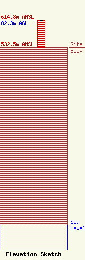
Site Elevation: 532.5 meters (1747 ft) |
| Height of Structure: 80.2 meters (263 feet) |
| Overall Height Above Ground: 82.3 meters (270 feet) |
| Overall Height Above Mean Sea Level: 614.8 meters (2017 feet) |
| Owner Info | NORTHWAY COMMUNICATIONS INC.
105 EAST OAK STREET
WAUASU, WI 54401
(715) 842-0841
don@northwaycom.com |
