|
|
Antenna Structure Registration 1242343 |
 |
Registration Info | Registration Number: 1242343 |
| File Number: A1377428 |
| FAA Study: 2003-ASW-5705-OE |
| FAA Issue Date: 01/21/2004 |
| Status: Constructed |
| Date Constructed: 02/21/2004 |
| FAA EMI: N |
| NEPA: N |
Structure Info
| Structure Type: BANT |
| Structure Coordinates: 32-55-41.5 N 96-49-21.0 W (NAD 83) |
| Structure Coordinates: 32-55-41.1 N 96-49-20.0 W (Converted to NAD 27) |
| Structure Address: 5005 L.b.j. Freeway |
| Structure City: Dallas, TX |
| Structure County: Dallas County |
| Painting & Lighting Info |
FCC Paragraph(s): 2 |
Remarks: PRIOR STUDY 1983-ASW-2605-OE |
Remarks: Continue As Is OM&L = RED LIGHTS |
Remarks: PRIOR STUDY 1983-ASW-2605-OE |
Remarks: Continue As Is OM&L = RED LIGHTS |
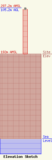
| Elevation Info |
Site Elevation: 192 meters (630 ft) |
| Height of Structure: 101.5 meters (333 feet) |
| Overall Height Above Ground: 105.2 meters (345 feet) |
| Overall Height Above Mean Sea Level: 297.2 meters (975 feet) |
| Owner Info | Occidental Tower Corp.
1600 Gehrig Drive
Midland, TX 79706
(713) 215-7569
fcc-faa@oxy.com |
| Contact Info | Keller and Heckman LLP
1001 G Street, NW, Suite 500 West
Washington, DC 20001
(202) 434-4100
telecomlicensing@khlaw.com |
