|
|
Antenna Structure Registration 1243073 |
 |
Registration Info | Registration Number: 1243073 |
| File Number: A0373845 |
| FAA Study: 2004-ASW-1402-OE |
| FAA Issue Date: 03/25/2004 |
| Status: Constructed |
| Date Constructed: 04/22/2004 |
| FAA EMI: N |
| NEPA: N |
Structure Info
| Structure Type: TOWER |
| Structure Coordinates: 35-19-24.3 N 94-19-1.6 W (NAD 83) |
| Structure Coordinates: 35-19-24.0 N 94-19-00.8 W (Converted to NAD 27) |
| Structure Address: Hwy 255 |
| Structure City: Barling, AR |
| Structure County: Sebastian County |
| Painting & Lighting Info |
FAA Chapters: NONE |
| Elevation Info |
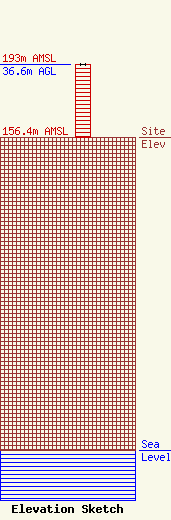
Site Elevation: 156.4 meters (513 ft) |
| Height of Structure: 36.6 meters (120 feet) |
| Overall Height Above Ground: 36.6 meters (120 feet) |
| Overall Height Above Mean Sea Level: 193 meters (633 feet) |
| Info |
| Contact Info | Graham Broack, Inc.
24466
St. Simons Island, GA 31522
Marilyn Matheny
(912) 638-8027
marilyn@grahambrock.com |
