|
|
Antenna Structure Registration 1243434 |
 |
Registration Info | Registration Number: 1243434 |
| File Number: A0377235 |
| FAA Study: 2004-ASO-2062-OE |
| FAA Issue Date: 05/04/2004 |
| Status: Constructed |
| Date Constructed: 05/17/2004 |
| FAA EMI: N |
| NEPA: N |
Structure Info
| Structure Type: TOWER |
| Structure Coordinates: 33-36-30.4 N 88-39-15.2 W (NAD 83) |
| Structure Coordinates: 33-36-30.0 N 88-39-15.0 W (Converted to NAD 27) |
| Structure Address: 413 North Forrest Street |
| Structure City: West Point, MS |
| Structure County: Clay County |
| Painting & Lighting Info |
FAA Chapters: NONE |
Remarks: PRIOR STUDY 2000-ASO-6830-OE |
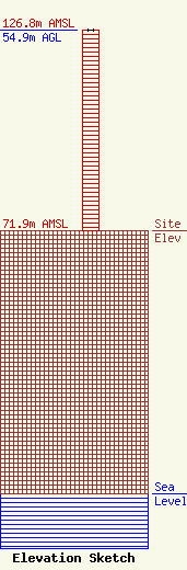
| Elevation Info |
Site Elevation: 71.9 meters (236 ft) |
| Height of Structure: 54.9 meters (180 feet) |
| Overall Height Above Ground: 54.9 meters (180 feet) |
| Overall Height Above Mean Sea Level: 126.8 meters (416 feet) |
| Owner Info | Telesouth Communications, Inc.
6311 Ridgewood Road
Jackson, MS 39211
(662) 494-1450
|
| Contact Info | Graham Brock, Inc.
24466
St. Simons Island, GA 31522
Marilyn Matheny
(912) 638-8028
marilyn@grahambrock.com |
