|
|
Antenna Structure Registration 1243867 |
 |
Registration Info | Registration Number: 1243867 |
| File Number: A1326040 |
| FAA Study: 2018-AGL-20227-OE |
| FAA Issue Date: 12/14/2018 |
| Status: Constructed |
| Date Constructed: 10/04/2019 |
| NEPA: N |
Structure Info
| Structure Type: MTOWER |
| Structure Coordinates: 47-18-41.0 N 96-31-14.0 W (NAD 83) |
| Structure Coordinates: 47-18-41.1 N 96-31-12.8 W (Converted to NAD 27) |
| Structure Address: North Of Intersection Of County Road 161 And W. Main Street |
| Structure City: Ada, MN |
| Structure County: Norman County |
| Painting & Lighting Info |
FAA Circular #: 70/7460-1L |
FAA Chapters: 3, 4, 5, 12 |
Remarks: PRIOR STUDY 2004-AGL-2542-OE |
| Elevation Info |
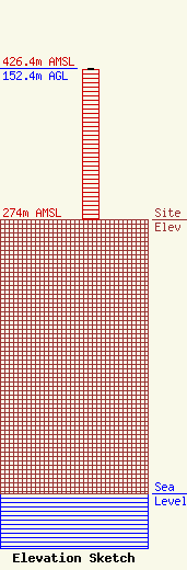
Site Elevation: 274 meters (899 ft) |
| Height of Structure: 151.5 meters (497 feet) |
| Overall Height Above Ground: 152.4 meters (500 feet) |
| Overall Height Above Mean Sea Level: 426.4 meters (1399 feet) |
| Owner Info | R&J Broadcasting, Inc.
312 West Main Street
Ada, MN 56510
(218) 784-6319
jim@rjbroadcasting.com |
| Contact Info | R&J Broadcasting, Inc.
312 West Main Street
Ada, MN 56510
Jimmy Birkemeyer
(218) 784-6319
jim@rjbroadcasting.com |
