|
|
Antenna Structure Registration 1244135 |
 |
Registration Info | Registration Number: 1244135 |
| File Number: A0684461 |
| FAA Study: 2003-ASO-6388-OE |
| FAA Issue Date: 07/25/2005 |
| Status: Constructed |
| Date Constructed: 02/06/2006 |
| FAA EMI: N |
| NEPA: N |
Structure Info
| Structure Type: TOWER |
| Structure Coordinates: 18-21-20.8 N 64-56-51.5 W (NAD 83) |
| Structure Coordinates: 18-21-28.0 N 64-56-53.0 W (Converted to NAD 27) |
| Structure Address: Atop Signal Hill, 1.3 Miles North Of Charlotte Amalie, St. Thomas, Virgin Island |
| Structure City: St. Thomas, VI |
| Structure County: St. Thomas Island |
| Painting & Lighting Info |
FAA Circular #: 70/7460-1K |
FAA Chapters: 4, 8, 12 |
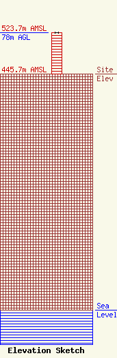
| Elevation Info |
Site Elevation: 445.7 meters (1462 ft) |
| Height of Structure: 78 meters (256 feet) |
| Overall Height Above Ground: 78 meters (256 feet) |
| Overall Height Above Mean Sea Level: 523.7 meters (1718 feet) |
| Owner Info | Virgin Islands Public Television System
3A-17 Mountain Top
7879
St. Thomas, VI 00801
(340) 774-6309
sjames@islands.vi |
| Contact Info | Kessler and Gehman Associates, Inc.
507-C N.W. 60th Street
Gainesville, FL 32607
Jeffrey Gehman
(352) 332-3157
jeff@kga.bz |
