|
|
Antenna Structure Registration 1245341 |
 |
Registration Info | Registration Number: 1245341 |
| File Number: A1022237 |
| FAA Study: 2006-AWP-2421-OE |
| FAA Issue Date: 05/17/2006 |
| Status: Constructed |
| Date Constructed: 06/01/2006 |
| FAA EMI: N |
| NEPA: N |
Structure Info
| Structure Type: TOWER |
| Structure Coordinates: 34-6-11.4 N 118-2-43.5 W (NAD 83) |
| Structure Coordinates: 34-06-11.4 N 118-02-40.3 W (Converted to NAD 27) |
| Structure Address: 5600 Gracewood Avenue (ie05408) |
| Structure City: Temple, CA |
| Structure County: Los Angeles County |
| Painting & Lighting Info |
FAA Chapters: NONE |
Remarks: PRIOR STUDY 2004-AWP-4566-OE |
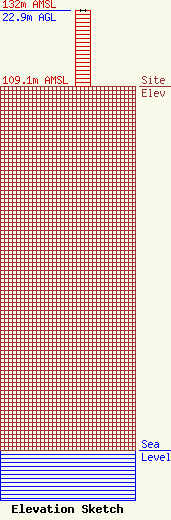
| Elevation Info |
Site Elevation: 109.1 meters (358 ft) |
| Height of Structure: 22.9 meters (75 feet) |
| Overall Height Above Ground: 22.9 meters (75 feet) |
| Overall Height Above Mean Sea Level: 132 meters (433 feet) |
| Owner Info | T-Mobile West Tower LLC
12920 SE 38th Street
Bellevue, WA 98006
(425) 383-8401
FCCRegulatoryComplianceContact@T-Mobile.com |
| Contact Info | Crown Castle
2000 Corporate Drive
Canonsburg, PA 15317
Don Snyder
(724) 416-2470
Don.Snyder@crowncastle.com |
