|
|
Antenna Structure Registration 1245606 |
 |
Registration Info | Registration Number: 1245606 |
| File Number: A1208067 |
| FAA Study: 2004-AEA-730-OE |
| FAA Issue Date: 05/06/2004 |
| Status: Constructed |
| Date Constructed: 06/20/2004 |
| FAA EMI: N |
| NEPA: N |
Structure Info
| Structure Type: TOWER |
| Structure Coordinates: 39-25-8.3 N 80-10-52.2 W (NAD 83) |
| Structure Coordinates: 39-25-08.0 N 80-10-52.9 W (Converted to NAD 27) |
| Structure Address: 7013 Mountain Park Drive |
| Structure City: Whitehall, WV |
| Structure County: Marion County |
| Painting & Lighting Info |
FAA Circular #: 70/7460-1K |
FAA Chapters: 3, 4, 5, 12 |
Remarks: Removed expiration and final dates from determination. Scenario 2./jjs/case#635066 |
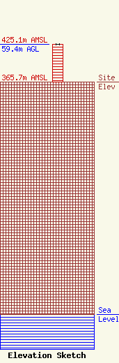
| Elevation Info |
Site Elevation: 365.7 meters (1200 ft) |
| Height of Structure: 59.4 meters (195 feet) |
| Overall Height Above Ground: 59.4 meters (195 feet) |
| Overall Height Above Mean Sea Level: 425.1 meters (1395 feet) |
| Owner Info | Mountain Gate Commons, LLC
668 Old Monongah Road
Fairmont, WV 26554
(304) 376-0296
chris@mountaingatecommons.com |
| Contact Info | Mountain Gate Commons, LLC
668 Old Monongah Road
Fairmont, WV 26554
Chris Egress
(304) 376-0296
chris@mountaingatecommons.com |
