|
|
Antenna Structure Registration 1245812 |
 |
Registration Info | Registration Number: 1245812 |
| File Number: A0781288 |
| FAA Study: 2007-AGL-4776-OE |
| FAA Issue Date: 07/05/2007 |
| Status: Constructed |
| Date Constructed: 12/10/2007 |
| FAA EMI: N |
| NEPA: N |
Structure Info
| Structure Type: TOWER |
| Structure Coordinates: 44-18-29.9 N 100-20-50.5 W (NAD 83) |
| Structure Coordinates: 44-18-30.0 N 100-20-49.0 W (Converted to NAD 27) |
| Structure Address: West Side Of Us-83, 1.5 Miles South Of Intersection Of Us-83 And Sd Hwy 1806. |
| Structure City: Fort Pierre, SD |
| Structure County: Stanley County |
| Painting & Lighting Info |
FAA Circular #: 70/7460-1K |
FAA Chapters: 3, 4, 5, 12 |
Remarks: OM&L to remain the same as prior study = PAINT/RED LIGHTS |
Remarks: PRIOR STUDY 2004-AGL-4596-OE |
Remarks: Removed expiration and final dates from determination. Scenario 2./jjs/case#635066 |
Remarks: PRIOR STUDY 2004-AGL-4596-OE |
Remarks: Removed expiration and final dates from determination. Scenario 2./jjs/case#635066 |
Remarks: OM&L to remain the same as prior study = PAINT/RED LIGHTS |
| Elevation Info |
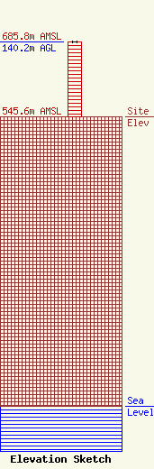
Site Elevation: 545.6 meters (1790 ft) |
| Height of Structure: 140.2 meters (460 feet) |
| Overall Height Above Ground: 140.2 meters (460 feet) |
| Overall Height Above Mean Sea Level: 685.8 meters (2250 feet) |
| Owner Info | James River Broadcasting Company
907
Valley City, ND 58072-0907
(701) 845-1490
janingstad@hotmail.com |
| Contact Info | Sciarrino & Shubert, PLLC
5425 Tree Line Drive
Centreville, VA 20120
Dawn Sciarrino
(202) 350-9658
dawn@sciarrinolaw.com |
