|
|
Antenna Structure Registration 1245893 |
 |
Registration Info | Registration Number: 1245893 |
| File Number: A1326041 |
| FAA Study: 85-AGL-1882-OE |
| FAA Issue Date: 01/15/1986 |
| Status: Constructed |
| Date Constructed: 05/01/1988 |
| FAA EMI: N |
| NEPA: N |
Structure Info
| Structure Type: TOWER |
| Structure Coordinates: 46-32-25.8 N 93-39-22.8 W (NAD 83) |
| Structure Coordinates: 46-32-26.0 N 93-39-21.9 W (Converted to NAD 27) |
| Structure Address: Aitkin. Mn |
| Structure City: Aitkin, MN |
| Structure County: Aitkin County |
| Painting & Lighting Info |
FCC Paragraph(s): 1, 3, 11, 21 |
Remarks: RED LIGHTS/PAINT |
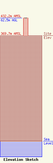
| Elevation Info |
Site Elevation: 369.7 meters (1213 ft) |
| Height of Structure: 62.5 meters (205 feet) |
| Overall Height Above Ground: 62.5 meters (205 feet) |
| Overall Height Above Mean Sea Level: 432.2 meters (1418 feet) |
| Owner Info | R&J Broadcasting, Inc.
312 West Main Street
Ada, MN 56510
(218) 784-6319
jim@rjbroadcasting.com |
| Contact Info | R&J Broadcasting, Inc.
312 West Main Street
Ada, MN 56510
Jimmy Birkemeyer
(218) 784-6319
jim@rjbroadcasting.com |
