|
|
Antenna Structure Registration 1247299 |
 |
Registration Info | Registration Number: 1247299 |
| File Number: A1282282 |
| FAA Study: 2004-AWP-2652-OE |
| FAA Issue Date: 06/24/2004 |
| Status: Constructed |
| Date Constructed: 09/11/2006 |
| FAA EMI: N |
| NEPA: N |
Structure Info
| Structure Type: 6TA1 |
| Structure Coordinates: 34-7-5.4 N 118-4-58.5 W (NAD 83) |
| Structure Coordinates: 34-07-05.4 N 118-04-55.3 W (Converted to NAD 27) |
| Structure Address: 6544 North Vista Street |
| Structure City: San Gabriel, CA |
| Structure County: Los Angeles County |
| Painting & Lighting Info |
FAA Chapters: NONE |
Remarks: PRIOR STUDY 2003-AWP-292-OE |
| Elevation Info |
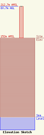
Site Elevation: 152 meters (499 ft) |
| Height of Structure: 60.7 meters (199 feet) |
| Overall Height Above Ground: 60.7 meters (199 feet) |
| Overall Height Above Mean Sea Level: 212.7 meters (698 feet) |
| Owner Info | Multicultural Radio Broadcasting, Inc.
40 Exchange Place, Suite 1010
New York, NY 10005
(212) 966-1059
brandonw@mrbi.net |
| Contact Info | Multicultural Radio Broadcasting, Inc.
40 Exchange Place, Suite 1010
New York, NY 10005
(212) 966-1059
brandonw@mrbi.net |
