|
|
Antenna Structure Registration 1247300 |
 |
Registration Info | Registration Number: 1247300 |
| File Number: A1282283 |
| FAA Study: 2004-AWP-2653-OE |
| FAA Issue Date: 06/24/2004 |
| Status: Constructed |
| Date Constructed: 09/12/2006 |
| FAA EMI: N |
| NEPA: N |
Structure Info
| Structure Type: 6TA2 |
| Structure Coordinates: 34-7-6.7 N 118-4-57.3 W (NAD 83) |
| Structure Coordinates: 34-07-06.7 N 118-04-54.1 W (Converted to NAD 27) |
| Structure Address: 6544 North Vista Street |
| Structure City: San Gabriel, CA |
| Structure County: Los Angeles County |
| Painting & Lighting Info |
FAA Circular #: 70/7460-1K |
FAA Chapters: 3, 12 |
| Elevation Info |
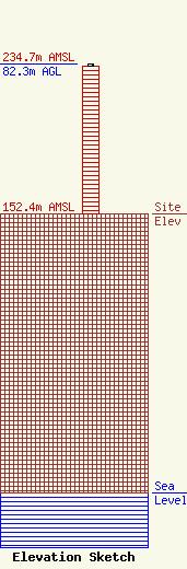
Site Elevation: 152.4 meters (500 ft) |
| Height of Structure: 81.5 meters (267 feet) |
| Overall Height Above Ground: 82.3 meters (270 feet) |
| Overall Height Above Mean Sea Level: 234.7 meters (770 feet) |
| Owner Info | Multicultural Radio Broadcasting, Inc.
40 Exchange Place, Suite 1010
New York, NY 10005
(212) 966-1059
brandonw@mrbi.net |
| Contact Info | Multicultural Radio Broadcasting, Inc.
40 Exchange Place, Suite 1010
New York, NY 10005
(212) 966-1059
brandonw@mrbi.net |
