|
|
Antenna Structure Registration 1249642 |
 |
Registration Info | Registration Number: 1249642 |
| File Number: A1150241 |
| FAA Study: 2005-ANE-339-OE |
| FAA Issue Date: 06/29/2005 |
| Status: Constructed |
| Date Constructed: 08/08/2005 |
| FAA EMI: N |
| NEPA: N |
Structure Info
| Structure Type: TOWER |
| Structure Coordinates: 46-40-59.4 N 68-0-55.9 W (NAD 83) |
| Structure Coordinates: 46-40-59.2 N 68-00-57.8 W (Converted to NAD 27) |
| Structure Address: 551 Main Street |
| Structure City: Presque Isle, ME |
| Structure County: Aroostook County |
| Painting & Lighting Info |
FAA Chapters: NONE |
Remarks: Removed expiration date from determination. Scenario 1./jjs/case#635066 |
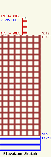
| Elevation Info |
Site Elevation: 133.5 meters (438 ft) |
| Height of Structure: 22.9 meters (75 feet) |
| Overall Height Above Ground: 22.9 meters (75 feet) |
| Overall Height Above Mean Sea Level: 156.4 meters (513 feet) |
| Owner Info | Cumulus Radio, LLC
3280 Peachtree Rd, Suite 2200
Atlanta, GA 30305
(404) 949-0700
towermanagement@cumulus.com |
| Contact Info | Cumulus Radio, LLC
2300 Vartan Way, Suite 130
Harrisburg, PA 17110
David Supplee
(717) 901-0720
dave.supplee@cumulus.com |
