|
|
Antenna Structure Registration 1249708 |
 |
Registration Info | Registration Number: 1249708 |
| File Number: A0974887 |
| FAA Study: 2005-ASO-3839-OE |
| FAA Issue Date: 08/09/2005 |
| Status: Constructed |
| Date Constructed: 01/25/2007 |
| FAA EMI: N |
| NEPA: N |
Structure Info
|
| Structure Coordinates: 35-15-27.2 N 83-47-43.4 W (NAD 83) |
| Structure Coordinates: 35-15-26.9 N 83-47-43.8 W (Converted to NAD 27) |
| Structure Address: Atop Joanna Bald |
| Structure City: Andrews, NC |
| Structure County: Graham County |
| Painting & Lighting Info |
FAA Chapters: NONE |
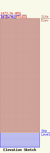
| Elevation Info |
Site Elevation: 1435.6 meters (4710 ft) |
| Height of Structure: 38.1 meters (125 feet) |
| Overall Height Above Ground: 38.1 meters (125 feet) |
| Overall Height Above Mean Sea Level: 1473.7 meters (4835 feet) |
| Owner Info | North Carolina State Highway Patrol
4231 MAIL SERVICE CENTER
Raleigh, NC 27699-4231
(888) 928-4737
viper.tsu-fsm@ncshp.org |
| Contact Info | North Carolina State Highway Patrol
4231 MAIL SERVICE CENTER
Raleigh, NC 27699-4231
Wayne Eberhard
(919) 948-7854
wayne.eberhard@ncdps.gov |
