|
|
Antenna Structure Registration 1250326 |
 |
Registration Info | Registration Number: 1250326 |
| File Number: A0570594 |
| FAA Study: 2005-AGL-4917-OE |
| FAA Issue Date: 09/28/2005 |
| Status: Constructed |
| Date Constructed: 01/15/1999 |
| FAA EMI: N |
| NEPA: N |
Structure Info
| Structure Type: BANT |
| Structure Coordinates: 42-59-51.9 N 84-10-15.2 W (NAD 83) |
| Structure Coordinates: 42-59-51.8 N 84-10-15.3 W (Converted to NAD 27) |
| Structure Address: 103 North Washington Street |
| Structure City: Owosso, MI |
| Structure County: Shiawassee County |
| Painting & Lighting Info |
FAA Chapters: NONE |
| Elevation Info |
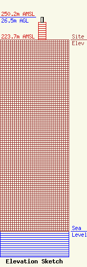
Site Elevation: 223.7 meters (734 ft) |
| Height of Structure: 20.4 meters (67 feet) |
| Overall Height Above Ground: 26.5 meters (87 feet) |
| Overall Height Above Mean Sea Level: 250.2 meters (821 feet) |
| Owner Info | KROL COMMUNICATIONS, INC. = STL
103 NORTH WASHINGTON STREET
OWOSSO, MI 48867
(989) 725-1925
RODKROL@VOYAGER.NET |
