|
|
Antenna Structure Registration 1251191 |
 |
Registration Info | Registration Number: 1251191 |
| File Number: A1198880 |
| FAA Study: 2005-AGL-5278-OE |
| FAA Issue Date: 10/06/2005 |
| Status: Constructed |
| Date Constructed: 11/11/2005 |
| NEPA: N |
Structure Info
|
| Structure Coordinates: 45-54-49.3 N 89-15-36.5 W (NAD 83) |
| Structure Coordinates: 45-54-49.5 N 89-15-36.0 W (Converted to NAD 27) |
| Structure Address: State Highway 70 West |
| Structure City: Eagle River, WI |
| Structure County: Vilas County |
| Painting & Lighting Info |
FAA Chapters: NONE |
Remarks: Removed expiration date from determination. Scenario 1./jjs/case#635066 |
| Elevation Info |
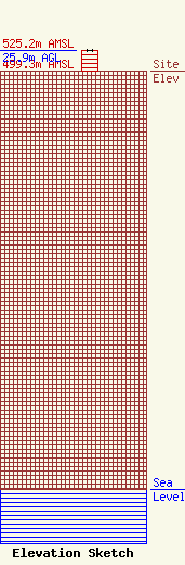
Site Elevation: 499.3 meters (1638 ft) |
| Height of Structure: 25.9 meters (85 feet) |
| Overall Height Above Ground: 25.9 meters (85 feet) |
| Overall Height Above Mean Sea Level: 525.2 meters (1723 feet) |
| Owner Info | Wausau TV License Company, LLC
1925 Century Park East
Los Angeles, CA 90067
(310) 277-3500
JeffreyM@es.tv |
| Contact Info | Nelson Mullins Riley & Scarborough LLP
101 Constitution Avenue, NW
Washington, DC 20001
Thomas Bardo
(202) 689-2817
tom.bardo@nelsonmullins.com |
