|
|
Antenna Structure Registration 1252267 |
 |
Registration Info | Registration Number: 1252267 |
| File Number: A0506353 |
| FAA Study: 2006-AWP-507-OE |
| FAA Issue Date: 02/06/2006 |
| Status: Constructed |
| Date Constructed: 04/03/2006 |
| FAA EMI: N |
| NEPA: N |
Structure Info
| Structure Type: TOWER |
| Structure Coordinates: 32-48-49.0 N 117-1-56.2 W (NAD 83) |
| Structure Coordinates: 32-48-48.8 N 117-01-53.1 W (Converted to NAD 27) |
| Structure Address: Cowles Mountain |
| Structure City: San Diego, CA |
| Structure County: San Diego County |
| Painting & Lighting Info |
FAA Chapters: NONE |
Remarks: PRIOR STUDY 2001-AWP-774-OE |
Remarks: Removed expiration date from determination. Scenario 1./jjs/case#635066 |
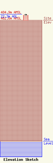
| Elevation Info |
Site Elevation: 462.6 meters (1518 ft) |
| Height of Structure: 18.6 meters (61 feet) |
| Overall Height Above Ground: 22.3 meters (73 feet) |
| Overall Height Above Mean Sea Level: 484.9 meters (1591 feet) |
| Owner Info | San Diego, City of
1220 Caminito Centro
San Diego, CA 92102
(619) 525-8650
knorton@sandiego.gov |
