|
|
Antenna Structure Registration 1253749 |
 |
Registration Info | Registration Number: 1253749 |
| File Number: A1066443 |
| FAA Study: 2013-ACE-3614-OE |
| FAA Issue Date: 12/30/2013 |
| Status: Constructed |
| Date Constructed: 01/17/2014 |
| NEPA: N |
Structure Info
| Structure Type: GTOWER |
| Structure Coordinates: 43-28-32.0 N 92-42-30.0 W (NAD 83) |
| Structure Coordinates: 43-28-32.1 N 92-42-29.3 W (Converted to NAD 27) |
| Structure Address: Ne Corner Of Quail Road And 490th Street |
| Structure City: Mcintire, IA |
| Structure County: Mitchell County |
| Painting & Lighting Info |
FAA Circular #: 70/7460-1K |
FAA Chapters: 3, 4, 5, 12 |
Remarks: FAA CHAPTERS 3,4,5,12; 70-7460-1K WITH BIRD LIGHTING DEVIATION SPECIAL CONDITION. PRIOR STUDY 2006-ACE-1148-OE. |
| Elevation Info |
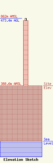
Site Elevation: 388.6 meters (1275 ft) |
| Height of Structure: 457.2 meters (1500 feet) |
| Overall Height Above Ground: 473.4 meters (1553 feet) |
| Overall Height Above Mean Sea Level: 862 meters (2828 feet) |
| Owner Info | Iowa Public Broadcast Board, DBA Iowa Public Television
6450
Johnston, IA 50131-6450
(515) 725-9765
hayes@iptv.org |
| Contact Info | Iowa Public Television
6450
Johnston, IA 50131
William Hayes
(515) 725-9765
hayes@iptv.org |
