|
|
Antenna Structure Registration 1254898 |
 |
Registration Info | Registration Number: 1254898 |
| File Number: A1385511 |
| FAA Study: 2018-ASW-14645-OE |
| FAA Issue Date: 11/13/2018 |
| Status: Constructed |
| Date Constructed: 10/20/2007 |
| NEPA: N |
Structure Info
| Structure Type: GTOWER |
| Structure Coordinates: 30-19-25.7 N 92-17-24.5 W (NAD 83) |
| Structure Coordinates: 30-19-25.0 N 92-17-24.0 W (Converted to NAD 27) |
| Structure Address: 2 Miles Sw Of Branch, La |
| Structure City: Branch, LA |
| Structure County: Acadia Parish |
| Painting & Lighting Info |
FAA Circular #: 70/7460-1K |
FAA Chapters: 4, 7, 12 |
Remarks: PRIOR STUDY 2005-ASW-4892-OE |
Remarks: OM&L to remain the same as prior study = 24-HR HI-STROBES |
Remarks: PRIOR STUDY 2005-ASW-4892-OE |
Remarks: OM&L to remain the same as prior study = 24-HR HI-STROBES |
| Elevation Info |
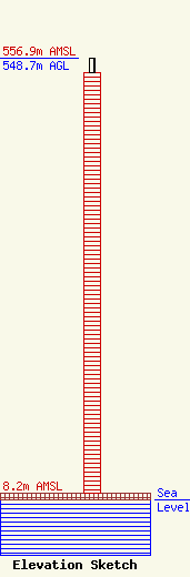
Site Elevation: 8.2 meters (27 ft) |
| Height of Structure: 530.4 meters (1740 feet) |
| Overall Height Above Ground: 548.7 meters (1800 feet) |
| Overall Height Above Mean Sea Level: 556.9 meters (1827 feet) |
| Owner Info | Gray Local Media, Inc.
4370 Peachtree Road, NE
Atlanta, GA 30319
(404) 504-9828
allfcclms@gray.tv |
| Contact Info | Cooley LLP
1299 Pennsylvania Ave., NW
Washington, DC 20004
Henry Wendel
(202) 776-2943
hwendel@cooley.com |
