|
|
Antenna Structure Registration 1257347 |
 |
Registration Info | Registration Number: 1257347 |
| File Number: A1022371 |
| FAA Study: 2006-AWP-7711-OE |
| FAA Issue Date: 02/20/2007 |
| Status: Constructed |
| Date Constructed: 09/17/2007 |
| FAA EMI: N |
| NEPA: N |
Structure Info
| Structure Type: TOWER |
| Structure Coordinates: 34-7-53.2 N 118-2-35.9 W (NAD 83) |
| Structure Coordinates: 34-07-53.2 N 118-02-32.7 W (Converted to NAD 27) |
| Structure Address: 375 Campus Drive (ie05407e) |
| Structure City: Arcadia, CA |
| Structure County: Los Angeles County |
| Painting & Lighting Info |
FAA Chapters: NONE |
Remarks: Removed expiration date from determination. Scenario 1./jjs/case#635066 |
| Elevation Info |
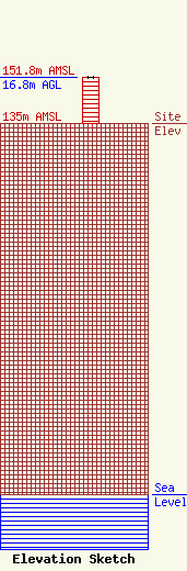
Site Elevation: 135 meters (443 ft) |
| Height of Structure: 16.8 meters (55 feet) |
| Overall Height Above Ground: 16.8 meters (55 feet) |
| Overall Height Above Mean Sea Level: 151.8 meters (498 feet) |
| Owner Info | T-Mobile West Tower LLC
12920 SE 38th Street
Bellevue, WA 98006
(425) 383-8401
FCCRegulatoryComplianceContact@T-Mobile.com |
| Contact Info | Crown Castle
2000 Corporate Drive
Canonsburg, PA 15317
Don Snyder
(724) 416-2470
Don.Snyder@crowncastle.com |
