|
|
Antenna Structure Registration 1258121 |
 |
Registration Info | Registration Number: 1258121 |
| File Number: A0592666 |
| FAA Study: 2007-AEA-1793-OE |
| FAA Issue Date: 04/12/2007 |
| Status: Constructed |
| Date Constructed: 03/17/2008 |
| FAA EMI: N |
| NEPA: N |
Structure Info
| Structure Type: TOWER |
| Structure Coordinates: 39-26-39.3 N 78-20-51.0 W (NAD 83) |
| Structure Coordinates: 39-26-39.0 N 78-20-52.0 W (Converted to NAD 27) |
| Structure Address: High Point, Hampshire County |
| Structure City: Ridge, WV |
| Structure County: Hampshire County |
| Painting & Lighting Info |
FAA Circular #: 70/7460-1K |
FAA Chapters: 4, 8, 12 |
Remarks: Removed expiration date from determination. Scenario 1./jjs/case#635066 |
Remarks: PRIOR STUDY 2007-AEA-669-OE |
| Elevation Info |
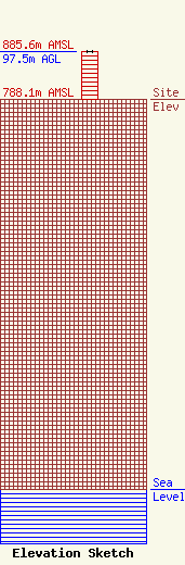
Site Elevation: 788.1 meters (2586 ft) |
| Height of Structure: 97.5 meters (320 feet) |
| Overall Height Above Ground: 97.5 meters (320 feet) |
| Overall Height Above Mean Sea Level: 885.6 meters (2906 feet) |
| Owner Info | Hampshire County Emergency Management/911
66 North High Street
806
Romney, WV 26757
(304) 822-7513
mikec@hampshireoes.com |
