|
|
Antenna Structure Registration 1258849 |
 |
Registration Info | Registration Number: 1258849 |
| File Number: A1247377 |
| FAA Study: 2007-ASW-3478-OE |
| FAA Issue Date: 06/05/2007 |
| Status: Constructed |
| Date Constructed: 08/25/2008 |
| FAA EMI: N |
| NEPA: N |
Structure Info
| Structure Type: TOWER |
| Structure Coordinates: 29-50-37.0 N 95-24-30.0 W (NAD 83) |
| Structure Coordinates: 29-50-36.2 N 95-24-29.2 W (Converted to NAD 27) |
| Structure Address: 5320 Shepard Drive |
| Structure City: Houston, TX |
| Structure County: Harris County |
| Painting & Lighting Info |
FAA Circular #: 70/7460-1K |
FAA Chapters: 4, 8, 12 |
Remarks: Removed expiration date from determination. Scenario 1./jjs/case#635066 |
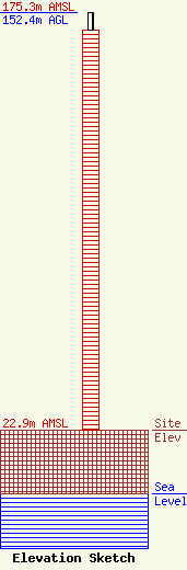
| Elevation Info |
Site Elevation: 22.9 meters (75 ft) |
| Height of Structure: 146.3 meters (480 feet) |
| Overall Height Above Ground: 152.4 meters (500 feet) |
| Overall Height Above Mean Sea Level: 175.3 meters (575 feet) |
| Owner Info | City of Houston Houston Information Technology Services Public Safety Communications Division
2318 Greens Rd.
Houston, TX 77032
(832) 393-0320
nicholas.curran@houstontx.gov |
| Contact Info | City of Houston Houston Information Technology Services Public Safety Communications Division
2318 Greens Rd
Houston, TX 77032
Mark Howell
(832) 393-0317
mark.howell@houstontx.gov |
