|
|
Antenna Structure Registration 1261105 |
 |
Registration Info | Registration Number: 1261105 |
| File Number: A1141366 |
| FAA Study: 2006-ASW-6138-OE |
| FAA Issue Date: 10/04/2006 |
| Status: Constructed |
| Date Constructed: 12/16/1991 |
| FAA EMI: N |
| NEPA: N |
Structure Info
| Structure Type: TOWER |
| Structure Coordinates: 29-55-24.7 N 89-58-52.2 W (NAD 83) |
| Structure Coordinates: 29-55-24.0 N 89-58-52.0 W (Converted to NAD 27) |
| Structure Address: Lower Coast Substation, 6500 Patterson Drive, New Orleans, La 70131 |
| Structure City: New Orleans, LA |
| Structure County: Orleans Parish |
| Painting & Lighting Info |
FAA Circular #: 70/7460-1K |
FAA Chapters: 4, 6, 12 |
Remarks: PRIOR STUDY 1991-ASW-1938-OE |
Remarks: Removed expiration date from determination. Scenario 1./jjs/case#635066 |
Remarks: PRIOR STUDY 1991-ASW-1938-OE |
| Elevation Info |
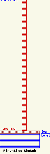
Site Elevation: 2.5 meters (8 ft) |
| Height of Structure: 134.7 meters (442 feet) |
| Overall Height Above Ground: 134.7 meters (442 feet) |
| Overall Height Above Mean Sea Level: 137.2 meters (450 feet) |
| Owner Info | Entergy Services, LLC
425 West Capitol Ave.
551
Little Rock, AR 72203-0551
(501) 377-5609
TelecomMgr@Entergy.com |
| Contact Info | Entergy Services, LLC
425 West Capitol Ave.
551
Little Rock, AR 72203-0551
Steven Paquette
(501) 377-5609
TelecomMgr@Entergy.com |
