|
|
Antenna Structure Registration 1262013 |
 |
Registration Info | Registration Number: 1262013 |
| File Number: A1282289 |
| FAA Study: 2006-AWP-4917-OE |
| FAA Issue Date: 11/14/2006 |
| Status: Constructed |
| Date Constructed: 12/23/2008 |
| FAA EMI: N |
| NEPA: N |
Structure Info
| Structure Type: TOWER |
| Structure Coordinates: 32-41-39.3 N 117-7-20.3 W (NAD 83) |
| Structure Coordinates: 32-41-39.1 N 117-07-17.2 W (Converted to NAD 27) |
| Structure Address: Off National Avenue |
| Structure City: San Diego, CA |
| Structure County: San Diego County |
| Painting & Lighting Info |
FAA Circular #: 70/7460-1K |
FAA Chapters: 4, 6, 12 |
Remarks: PRIOR STUDY 1997-AWP-683-OE |
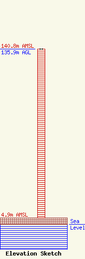
| Elevation Info |
Site Elevation: 4.9 meters (16 ft) |
| Height of Structure: 135.6 meters (445 feet) |
| Overall Height Above Ground: 135.9 meters (446 feet) |
| Overall Height Above Mean Sea Level: 140.8 meters (462 feet) |
| Owner Info | Multicultural Radio Broadcasting, Inc.
40 Exchange Place, Suite 1010
New York, NY 10005
(212) 966-1059
brandonw@mrbi.net |
| Contact Info | Multicultural Radio Broadcasting, Inc.
40 Exchange Place, Suite 1010
New York, NY 10005
(212) 966-1059
brandonw@mrbi.net |
