|
|
Antenna Structure Registration 1263739 |
 |
Registration Info | Registration Number: 1263739 |
| File Number: A1238835 |
| FAA Study: 2022-ASW-17115-OE |
| FAA Issue Date: 11/10/2022 |
| Status: Granted |
| Date Constructed: 03/18/2009 |
| NEPA: N |
Structure Info
| Structure Type: GTOWER |
| Structure Coordinates: 34-47-50.6 N 92-29-20.8 W (NAD 83) |
| Structure Coordinates: 34-47-50.3 N 92-29-20.2 W (Converted to NAD 27) |
| Structure Address: Shinall Mountain Antenna Farm |
| Structure City: Little Rock, AR |
| Structure County: Pulaski County |
| Painting & Lighting Info |
FAA Circular #: 70/7460-1M |
FAA Chapters: 4, 9, 15 |
Remarks: PRIOR STUDY 2021-ASW-7632-OE |
| Elevation Info |
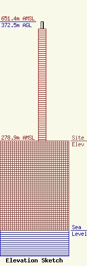
Site Elevation: 278.9 meters (915 ft) |
| Height of Structure: 350.5 meters (1150 feet) |
| Overall Height Above Ground: 372.5 meters (1222 feet) |
| Overall Height Above Mean Sea Level: 651.4 meters (2137 feet) |
| Owner Info | KATV Licensee, LLC
10706 Beaver Dam Road
Cockeysville, MD 21030
(410) 568-1500
harnold@sbgtv.com |
| Contact Info | Lerman Senter PLLC
2001 L Street NW Ste 400
Washington, DC 20036
(202) 429-8970
pcicelski@lermansenter.com |
