|
|
Antenna Structure Registration 1264722 |
 |
Registration Info | Registration Number: 1264722 |
| File Number: A1050707 |
| FAA Study: 2007-AGL-8823-OE |
| FAA Issue Date: 11/15/2007 |
| Status: Constructed |
| Date Constructed: 08/22/2008 |
| FAA EMI: N |
| NEPA: N |
Structure Info
| Structure Type: TOWER |
| Structure Coordinates: 43-34-59.1 N 84-46-6.9 W (NAD 83) |
| Structure Coordinates: 43-34-59.0 N 84-46-06.9 W (Converted to NAD 27) |
| Structure Address: 707 E. Broomfield |
| Structure City: Mount Pleasant, MI |
| Structure County: Isabella County |
| Painting & Lighting Info |
FAA Chapters: NONE |
Remarks: Removed expiration date from determination. Scenario 1./jjs/case#635066 |
| Elevation Info |
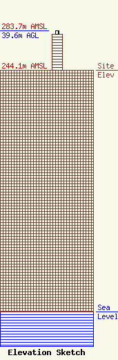
Site Elevation: 244.1 meters (801 ft) |
| Height of Structure: 36.6 meters (120 feet) |
| Overall Height Above Ground: 39.6 meters (130 feet) |
| Overall Height Above Mean Sea Level: 283.7 meters (931 feet) |
| Owner Info | CMU Public Broadcasting
1999 East Campus Drive
Mt. Pleasant, MI 48859
(989) 774-3105
wayne.h@cmich.edu |
| Contact Info | CMU Public Broadcasting
1999 East Campus Drive
Mt. Pleasant, MI 48859
(989) 774-3105
wayne.h@cmich.edu |
