|
|
Antenna Structure Registration 1267265 |
 |
Registration Info | Registration Number: 1267265 |
| File Number: A1159638 |
| FAA Study: 2009-ASW-215-OE |
| FAA Issue Date: 01/30/2009 |
| Status: Constructed |
| Date Constructed: 06/01/2009 |
| NEPA: N |
Structure Info
| Structure Type: GTOWER |
| Structure Coordinates: 30-9-20.7 N 93-59-10.6 W (NAD 83) |
| Structure Coordinates: 30-09-19.9 N 93-59-10.0 W (Converted to NAD 27) |
| Structure Address: 2.4 Miles South Off Highway 12 In Vidor, Texas |
| Structure City: Beaumont, TX |
| Structure County: Orange County |
| Painting & Lighting Info |
FAA Circular #: 70/7460-1K |
FAA Chapters: 3, 4, 5, 12 |
Remarks: RED LIGHTS/PAINT - REFERENCE ADDITIONAL INFORMATION ON FAA STUDY. PRIOR STUDY 2008-ASW-6977-OE |
| Elevation Info |
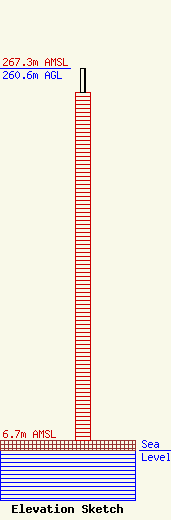
Site Elevation: 6.7 meters (22 ft) |
| Height of Structure: 243.8 meters (800 feet) |
| Overall Height Above Ground: 260.6 meters (855 feet) |
| Overall Height Above Mean Sea Level: 267.3 meters (877 feet) |
| Owner Info | San Antonio Television, LLC
c/o Pillsbury Winthrop Shaw Pittman
Washington, DC 20036
(202) 663-8195
miles.mason@pillsburylaw.com |
| Contact Info | Pillsbury Winthrop Shaw Pittman LLP
1200 Seventeenth Street, NW
Washington, DC 20036
Miles Mason
(202) 663-8195
miles.mason@pillsburylaw.com |
