|
|
Antenna Structure Registration 1267806 |
 |
Registration Info | Registration Number: 1267806 |
| File Number: A1262040 |
| FAA Study: 2008-ASO-6556-OE |
| FAA Issue Date: 01/29/2009 |
| Status: Constructed |
| Date Constructed: 04/02/2009 |
| FAA EMI: N |
| NEPA: N |
Structure Info
| Structure Type: TOWER |
| Structure Coordinates: 33-58-19.2 N 84-30-8.3 W (NAD 83) |
| Structure Coordinates: 33-58-18.8 N 84-30-08.5 W (Converted to NAD 27) |
| Structure Address: 1480 Barnes Mill Rd |
| Structure City: Marietta, GA |
| Structure County: Cobb County |
| Painting & Lighting Info |
FAA Circular #: 70/7460-1K |
FAA Chapters: 4, 8, 12 |
Remarks: PRIOR STUDY 1981-ASO-1533-OE |
| Elevation Info |
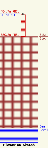
Site Elevation: 386.2 meters (1267 ft) |
| Height of Structure: 92.4 meters (303 feet) |
| Overall Height Above Ground: 98.5 meters (323 feet) |
| Overall Height Above Mean Sea Level: 484.7 meters (1590 feet) |
| Owner Info | EIP Communications I, LLC
Two Allegheny Center, Nova Tower 2
Pittsburgh, PA 15212
(844) 282-7748
regulatory@everestinfrastructure.com |
| Contact Info | EIP Communications I, LLC
Two Allegheny Center, Nova Tower 2
Pittsburgh, PA 15212
Justin Burgess
(844) 282-7748
regulatory@everestinfrastructure.com |
