|
|
Antenna Structure Registration 1268186 |
 |
Registration Info | Registration Number: 1268186 |
| File Number: A0740860 |
| FAA Study: 2009-AWP-697-OE |
| FAA Issue Date: 03/23/2009 |
| Status: Constructed |
| Date Constructed: 10/25/2011 |
| FAA EMI: N |
| NEPA: N |
Structure Info
| Structure Type: SIGN |
| Structure Coordinates: 36-35-38.0 N 115-37-58.8 W (NAD 83) |
| Structure Coordinates: 36-35-38.1 N 115-37-55.7 W (Converted to NAD 27) |
| Structure Address: Near Creech Afb |
| Structure City: Indian Springs, NV |
| Structure County: Clark County |
| Painting & Lighting Info |
FAA Chapters: NONE |
Remarks: Removed expiration and final dates from determination. Scenario 2./jjs/case#635066 |
| Elevation Info |
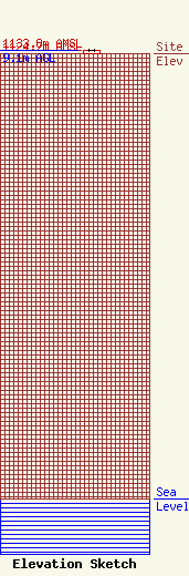
Site Elevation: 1124.7 meters (3690 ft) |
| Height of Structure: 9.1 meters (30 feet) |
| Overall Height Above Ground: 9.1 meters (30 feet) |
| Overall Height Above Mean Sea Level: 1133.8 meters (3720 feet) |
| Owner Info | Clark, County of
1670 Pinto Ln
Las Vegas, NV 89106
(702) 455-4746
aga@co.clark.nv |
| Info |
