|
|
Antenna Structure Registration 1268388 |
 |
Registration Info | Registration Number: 1268388 |
| File Number: A1172095 |
| FAA Study: 2020-AGL-5236-OE |
| FAA Issue Date: 03/26/2020 |
| Status: Constructed |
| Date Constructed: 08/12/2020 |
| NEPA: N |
Structure Info
| Structure Type: LTOWER |
| Structure Coordinates: 39-12-34.1 N 86-38-31.1 W (NAD 83) |
| Structure Coordinates: 39-12-33.9 N 86-38-31.1 W (Converted to NAD 27) |
| Structure Address: 4071 N Louden Rd |
| Structure City: Bloomington, IN |
| Structure County: Monroe County |
| Painting & Lighting Info |
FAA Circular #: 70/7460-1L |
FAA Chapters: 4, 8, 12 |
| Elevation Info |
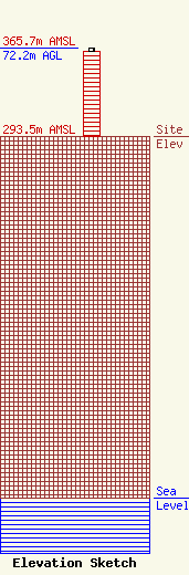
Site Elevation: 293.5 meters (963 ft) |
| Height of Structure: 70.1 meters (230 feet) |
| Overall Height Above Ground: 72.2 meters (237 feet) |
| Overall Height Above Mean Sea Level: 365.7 meters (1200 feet) |
| Owner Info | Hoosier Energy Rural Electric Cooperative, Inc.
2501 S Cooperative Way
908
Bloomington, IN 47402-0908
(812) 876-2021
cthomas@hepn.com |
| Contact Info | Hoosier Energy Rural Electric Cooperative, Inc.
2501 S Cooperative Way
908
Bloomington, IN 47402-0908
Caleb Thomas
(812) 876-0366
cthomas@hepn.com |
