|
|
Antenna Structure Registration 1268745 |
 |
Registration Info | Registration Number: 1268745 |
| File Number: A0680058 |
| FAA Study: 2009-ASW-2396-OE |
| FAA Issue Date: 06/02/2009 |
| Status: Constructed |
| Date Constructed: 03/20/2010 |
| FAA EMI: N |
| NEPA: N |
Structure Info
| Structure Type: TOWER |
| Structure Coordinates: 35-22-12.8 N 99-37-41.5 W (NAD 83) |
| Structure Coordinates: 35-22-12.6 N 99-37-40.1 W (Converted to NAD 27) |
| Structure Address: 0.6 Mile East Of Us 283; 4.3 Miles Of The Junction Of Us 283 And North Highway 6 |
| Structure City: Sayre, OK |
| Structure County: Beckham County |
| Painting & Lighting Info |
FAA Circular #: 70/7460-1K |
FAA Chapters: 4, 6, 12 |
Remarks: Removed expiration date from determination. Scenario 1./jjs/case#635066 |
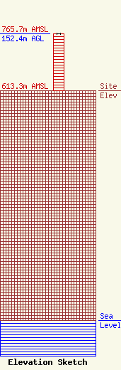
| Elevation Info |
Site Elevation: 613.3 meters (2012 ft) |
| Height of Structure: 151.5 meters (497 feet) |
| Overall Height Above Ground: 152.4 meters (500 feet) |
| Overall Height Above Mean Sea Level: 765.7 meters (2512 feet) |
| Owner Info | Wright Broadcasting Systems, Inc.
10040 Highway 54
Weatherford, OK 73096
(580) 772-5939
|
| Contact Info | Graham Brock, Inc.
24466
St. Simons Island, GA 31522-7466
Marilyn Matheny
(912) 638-8028
marilyn@grahambrock.com |
