|
|
Antenna Structure Registration 1268884 |
 |
Registration Info | Registration Number: 1268884 |
| File Number: A1225636 |
| FAA Study: 2022-AWP-1476-OE |
| FAA Issue Date: 08/03/2022 |
| Status: Constructed |
| Date Constructed: 04/13/2009 |
| NEPA: N |
Structure Info
| Structure Type: TREE |
| Structure Coordinates: 34-8-17.3 N 118-6-4.4 W (NAD 83) |
| Structure Coordinates: 34-08-17.3 N 118-06-01.1 W (Converted to NAD 27) |
| Structure Address: 460 S. Sierra Madre Blvd. (ca12889-a) |
| Structure City: Pasadena, CA |
| Structure County: Los Angeles County |
| Painting & Lighting Info |
FAA Chapters: NONE |
Remarks: PRIOR STUDY 2010-AWP-7722-OE |
| Elevation Info |
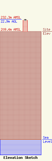
Site Elevation: 209.4 meters (687 ft) |
| Height of Structure: 21.3 meters (70 feet) |
| Overall Height Above Ground: 22.9 meters (75 feet) |
| Overall Height Above Mean Sea Level: 232.3 meters (762 feet) |
| Owner Info | SBA Towers III LLC
8051 Congress Avenue
Boca Raton, FL 33487
(561) 995-7670
ERoach@sbasite.com |
| Contact Info | SBA Towers III LLC
8051 Congress Avenue
Boca Raton, FL 33487
(561) 995-7670
ERoach@sbasite.com |
