|
|
Antenna Structure Registration 1269070 |
 |
Registration Info | Registration Number: 1269070 |
| File Number: A0694015 |
| FAA Study: 2009-AGL-2633-OE |
| FAA Issue Date: 07/08/2009 |
| Status: Constructed |
| Date Constructed: 08/06/2009 |
| FAA EMI: N |
| NEPA: N |
Structure Info
| Structure Type: TOWER |
| Structure Coordinates: 42-1-2.6 N 87-54-46.0 W (NAD 83) |
| Structure Coordinates: 42-01-02.5 N 87-54-45.8 W (Converted to NAD 27) |
| Structure Address: 424 E. Howard Ave. |
| Structure City: Des Plaines, IL |
| Structure County: Cook County |
| Painting & Lighting Info |
FAA Chapters: NONE |
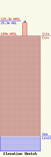
| Elevation Info |
Site Elevation: 199 meters (653 ft) |
| Height of Structure: 25.8 meters (85 feet) |
| Overall Height Above Ground: 29.3 meters (96 feet) |
| Overall Height Above Mean Sea Level: 228.3 meters (749 feet) |
| Owner Info | NBC Universal, Inc.
1299 Pennsylvania Ave 9th Fl
Washington, DC 20004
(202) 637-4262
Margaret.Tobey@NBCUni.com |
| Contact Info | NBC Universal, Inc.
1299 Pennsylvania Avenue, 9th Fl
Washington, DC 20004
Margaret Tobey
(202) 637-4262
Margaret.Tobey@NBCUni.com |
