|
|
Antenna Structure Registration 1270370 |
 |
Registration Info | Registration Number: 1270370 |
| File Number: A0697630 |
| FAA Study: 2009-ASW-4015-OE |
| FAA Issue Date: 09/01/2009 |
| Status: Constructed |
| Date Constructed: 09/03/2009 |
| FAA EMI: N |
| NEPA: N |
Structure Info
| Structure Type: TOWER |
| Structure Coordinates: 33-22-55.9 N 96-25-14.2 W (NAD 83) |
| Structure Coordinates: 33-22-55.5 N 96-25-13.3 W (Converted to NAD 27) |
| Structure Address: 3/4 Mi Sw, 400 Yds N Hwy 121 |
| Structure City: Desert, TX |
| Structure County: Collin County |
| Painting & Lighting Info |
FCC Paragraph(s): 1, 3, 12, 21 |
Remarks: PRIOR STUDY 1985-ASW-2202-OE |
Remarks: Continue As Is OM&L = PAINT/RED LIGHTS |
| Elevation Info |
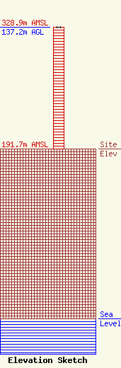
Site Elevation: 191.7 meters (629 ft) |
| Height of Structure: 137.2 meters (450 feet) |
| Overall Height Above Ground: 137.2 meters (450 feet) |
| Overall Height Above Mean Sea Level: 328.9 meters (1079 feet) |
| Info |
