|
|
Antenna Structure Registration 1271299 |
 |
Registration Info | Registration Number: 1271299 |
| File Number: A0783534 |
| FAA Study: 2009-AWP-4938-OE |
| FAA Issue Date: 10/09/2009 |
| Status: Constructed |
| Date Constructed: 08/02/2007 |
| FAA EMI: N |
| NEPA: N |
Structure Info
| Structure Type: TOWER |
| Structure Coordinates: 34-7-5.5 N 118-2-54.2 W (NAD 83) |
| Structure Coordinates: 34-07-05.5 N 118-02-51.0 W (Converted to NAD 27) |
| Structure Address: 460-1/2 Lemon Avenue (ie24055c) |
| Structure City: Arcadia, CA |
| Structure County: Los Angeles County |
| Painting & Lighting Info |
FAA Chapters: NONE |
Remarks: PRIOR STUDY 2007-AWP-106-OE |
| Elevation Info |
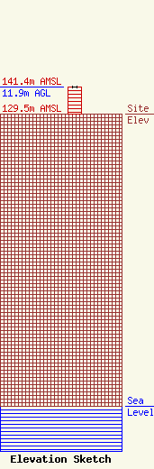
Site Elevation: 129.5 meters (425 ft) |
| Height of Structure: 11.9 meters (39 feet) |
| Overall Height Above Ground: 11.9 meters (39 feet) |
| Overall Height Above Mean Sea Level: 141.4 meters (464 feet) |
| Owner Info | T-Mobile West LLC
12920 SE 38th Street
Bellevue, WA 98006
(425) 383-8401
FCCRegulatoryComplianceContact@T-Mobile.com |
| Contact Info | T-Mobile West LLC
12920 SE 38th Street
Bellevue, WA 98006
(425) 383-8401
FCCRegulatoryComplianceContact@T-mobile.com |
