|
|
Antenna Structure Registration 1271505 |
 |
Registration Info | Registration Number: 1271505 |
| File Number: A1220506 |
| FAA Study: 2022-AWP-14246-OE |
| FAA Issue Date: 07/22/2022 |
| Status: Constructed |
| Date Constructed: 03/25/1999 |
| NEPA: N |
Structure Info
| Structure Type: POLE |
| Structure Coordinates: 34-8-13.1 N 117-58-35.8 W (NAD 83) |
| Structure Coordinates: 34-08-13.1 N 117-58-32.6 W (Converted to NAD 27) |
| Structure Address: 1400 Buena Vista St. (ca45398-a) |
| Structure City: Duarte, CA |
| Structure County: Los Angeles County |
| Painting & Lighting Info |
FAA Chapters: NONE |
Remarks: PRIOR STUDY 1998-AWP-1423-OE |
| Elevation Info |
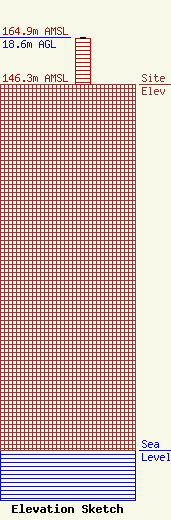
Site Elevation: 146.3 meters (480 ft) |
| Height of Structure: 18.3 meters (60 feet) |
| Overall Height Above Ground: 18.6 meters (61 feet) |
| Overall Height Above Mean Sea Level: 164.9 meters (541 feet) |
| Owner Info | SBA 2012 TC Assets, LLC
8051 Congress Avenue
Boca Raton, FL 33487
(561) 995-7670
ERoach@sbasite.com |
| Contact Info | SBA 2012 TC Assets, LLC
8051 Congress Avenue
Boca Raton, FL 33487
(561) 995-7670
ERoach@sbasite.com |
