|
|
Antenna Structure Registration 1272770 |
 |
Registration Info | Registration Number: 1272770 |
| File Number: A0990343 |
| FAA Study: 2009-AWP-3860-OE |
| FAA Issue Date: 01/14/2011 |
| Status: Constructed |
| Date Constructed: 04/04/2011 |
| FAA EMI: N |
| NEPA: N |
Structure Info
| Structure Type: TOWER |
| Structure Coordinates: 34-6-32.2 N 118-3-12.1 W (NAD 83) |
| Structure Coordinates: 34-06-32.2 N 118-03-08.9 W (Converted to NAD 27) |
| Structure Address: 6019 Baldwin Avenue |
| Structure City: Temple City, CA |
| Structure County: Los Angeles County |
| Painting & Lighting Info |
FAA Chapters: NONE |
Remarks: Removed expiration date from determination. Scenario 1./jjs/case#635066 |
| Elevation Info |
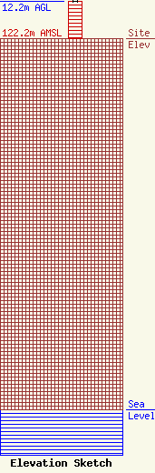
Site Elevation: 122.2 meters (401 ft) |
| Height of Structure: 12.2 meters (40 feet) |
| Overall Height Above Ground: 12.2 meters (40 feet) |
| Overall Height Above Mean Sea Level: 134.4 meters (441 feet) |
| Owner Info | Los Angeles SMSA Limited Partnership
1120 Sanctuary Pkwy
Alpharetta, GA 30009
(770) 797-1070
Network.Regulatory@VerizonWireless.com |
| Contact Info | Los Angeles SMSA Limited Partnership
1120 Sanctuary Pkwy
Alpharetta, GA 30009
Regulatory Manager
(770) 797-1070
Network.Regulatory@VerizonWireless.com |
