|
|
Antenna Structure Registration 1273391 |
 |
Registration Info | Registration Number: 1273391 |
| File Number: A0932074 |
| FAA Study: 2010-AGL-613-OE |
| FAA Issue Date: 03/03/2010 |
| Status: Constructed |
| Date Constructed: 09/01/2010 |
| FAA EMI: N |
| NEPA: N |
Structure Info
| Structure Type: TOWER |
| Structure Coordinates: 38-5-39.0 N 87-41-39.0 W (NAD 83) |
| Structure Coordinates: 38-05-38.8 N 87-41-38.9 W (Converted to NAD 27) |
| Structure Address: St. Wendel Road |
| Structure City: Evansville, IN |
| Structure County: Vanderburgh County |
| Painting & Lighting Info |
FAA Chapters: NONE |
| Elevation Info |
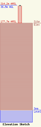
Site Elevation: 177.7 meters (583 ft) |
| Height of Structure: 35 meters (115 feet) |
| Overall Height Above Ground: 36.5 meters (120 feet) |
| Overall Height Above Mean Sea Level: 214.2 meters (703 feet) |
| Owner Info | The Original Company, Inc.
522 Busseron St.
242
Vincennes, IN 47591
(812) 882-6060
marklange@originalcompany.com |
