|
|
Antenna Structure Registration 1275264 |
 |
Registration Info | Registration Number: 1275264 |
| File Number: A1050709 |
| FAA Study: 2010-AGL-3686-OE |
| FAA Issue Date: 07/28/2010 |
| Status: Constructed |
| Date Constructed: 11/19/1996 |
| FAA EMI: N |
| NEPA: N |
Structure Info
| Structure Type: TOWER |
| Structure Coordinates: 43-34-33.3 N 84-46-29.1 W (NAD 83) |
| Structure Coordinates: 43-34-33.2 N 84-46-29.0 W (Converted to NAD 27) |
| Structure Address: 0.4mi West Of Us-127 Bus. 0.1mi Ne Of Corner Of W. Campus Dr. And 3 Leaves Dr. |
| Structure City: Mt. Pleasant, MI |
| Structure County: Isabella County |
| Painting & Lighting Info |
FAA Circular #: 70/7460-1J |
FAA Chapters: 3, 4, 5, 13 |
Remarks: OM&L to remain the same as prior study = PAINT/RED LIGHTS |
Remarks: PRIOR STUDY 1996-AGL-2690-OE |
Remarks: OM&L to remain the same as prior study = PAINT/RED LIGHTS |
Remarks: PRIOR STUDY 1996-AGL-2690-OE |
| Elevation Info |
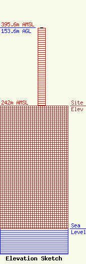
Site Elevation: 242 meters (794 ft) |
| Height of Structure: 152.6 meters (501 feet) |
| Overall Height Above Ground: 153.6 meters (504 feet) |
| Overall Height Above Mean Sea Level: 395.6 meters (1298 feet) |
| Owner Info | CMU Public Broadcasting
1999 East Campus Drive
Mt. Pleasant, MI 48859
(989) 774-3105
wayne.h@cmich.edu |
| Contact Info | CMU Public Broadcasting
1999 East Campus Drive
Mt. Pleasant, MI 48859
(989) 774-3105
wayne.h@cmich.edu |
