|
|
Antenna Structure Registration 1275399 |
 |
Registration Info | Registration Number: 1275399 |
| File Number: A1252027 |
| FAA Study: 2023-ASW-11388-OE |
| FAA Issue Date: 08/22/2023 |
| Status: Constructed |
| Date Constructed: 03/27/2011 |
| NEPA: N |
Structure Info
| Structure Type: LTOWER |
| Structure Coordinates: 32-39-44.4 N 97-17-37.6 W (NAD 83) |
| Structure Coordinates: 32-39-43.9 N 97-17-36.5 W (Converted to NAD 27) |
| Structure Address: 2500 Se Loop 820 |
| Structure City: Fort Worth, TX |
| Structure County: Tarrant County |
| Painting & Lighting Info |
FAA Circular #: 70/7460-1M |
FAA Chapters: 4, 8, 15 |
Remarks: PRIOR STUDY 2008-ASW-6801-OE |
| Elevation Info |
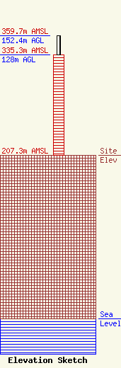
Site Elevation: 207.3 meters (680 ft) |
| Height of Structure: 128 meters (420 feet) |
| Overall Height Above Ground: 152.4 meters (500 feet) |
| Overall Height Above Mean Sea Level: 359.7 meters (1180 feet) |
| Owner Info | City of Fort Worth
1000 Throckmorton
Fort Worth, TX 76102
(817) 392-2401
lawrence.crockett@fortworthgov.org |
| Contact Info | City of Fort Worth
1000 Throckmorton
Fort Worth, TX 76102
Lawrence Crockett
(817) 392-2401
lawrence.crockett@fortworthgov.org |
