|
|
Antenna Structure Registration 1276476 |
 |
Registration Info | Registration Number: 1276476 |
| File Number: A1180304 |
| FAA Study: 2010-ASW-2662-OE |
| FAA Issue Date: 06/09/2010 |
| Status: Constructed |
| Date Constructed: 09/20/2010 |
| FAA EMI: N |
| NEPA: N |
Structure Info
| Structure Type: TOWER |
| Structure Coordinates: 34-45-45.3 N 92-29-42.6 W (NAD 83) |
| Structure Coordinates: 34-45-45.0 N 92-29-42.0 W (Converted to NAD 27) |
| Structure Address: 20001 Kanis Road |
| Structure City: Little Rock, AR |
| Structure County: Pulaski County |
| Painting & Lighting Info |
FAA Chapters: NONE |
Remarks: Removed expiration date from determination. Scenario 1./jjs/case#635066 |
| Elevation Info |
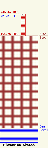
Site Elevation: 194.7 meters (639 ft) |
| Height of Structure: 45.7 meters (150 feet) |
| Overall Height Above Ground: 45.7 meters (150 feet) |
| Overall Height Above Mean Sea Level: 240.4 meters (789 feet) |
| Owner Info | Crown Castle USA Inc.
2000 Corporate Drive
15317
Canonsburg, PA 15317
(724) 416-2000
regulatory.department@crowncastle.com |
| Contact Info | Crown Castle Towers 06-2 LLC
2000 Corporate Drive
Canonsburg, PA 15317
Don Snyder
(724) 416-2000
regulatory.department@crowncastle.com |
