|
|
Antenna Structure Registration 1276800 |
 |
Registration Info | Registration Number: 1276800 |
| File Number: A0998562 |
| FAA Study: 2010-AWP-6392-OE |
| FAA Issue Date: 11/16/2010 |
| Status: Dismantled |
| Date Constructed: 04/21/2011 |
| FAA EMI: N |
| NEPA: N |
Structure Info
| Structure Type: BPIPE |
| Structure Coordinates: 34-11-59.5 N 118-10-37.1 W (NAD 83) |
| Structure Coordinates: 34-11-59.5 N 118-10-33.8 W (Converted to NAD 27) |
| Structure Address: 4815 Oakgrove Drive |
| Structure City: La Canada, CA |
| Structure County: Los Angeles County |
| Painting & Lighting Info |
FAA Chapters: NONE |
| Elevation Info |
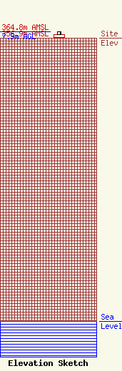
Site Elevation: 356.9 meters (1171 ft) |
| Height of Structure: 4.7 meters (15 feet) |
| Overall Height Above Ground: 7.9 meters (26 feet) |
| Overall Height Above Mean Sea Level: 364.8 meters (1197 feet) |
| Owner Info | Pacific Bell Telephone Company d/b/a AT&T California
8089 South Avenue
Boardman, OH 44512
(724) 651-6312
jon.kaufman@att.com |
| Contact Info | AT&T
8089 South Avenue
Boardman, OH 44512
(724) 651-6312
jon.kaufman@att.com |
