|
|
Antenna Structure Registration 1281388 |
 |
Registration Info | Registration Number: 1281388 |
| File Number: A1344070 |
| FAA Study: 2011-ASO-7014-OE |
| FAA Issue Date: 11/14/2011 |
| Status: Constructed |
| Date Constructed: 01/01/1940 |
| NEPA: N |
Structure Info
|
| Structure Coordinates: 35-11-41.1 N 90-0-33.1 W (NAD 83) |
| Structure Coordinates: 35-11-40.8 N 90-00-32.8 W (Converted to NAD 27) |
| Structure Address: 2531 N Watkins St |
| Structure City: Memphis, TN |
| Structure County: Shelby County |
| Painting & Lighting Info |
FAA Chapters: NONE |
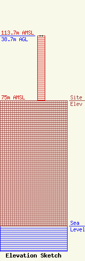
| Elevation Info |
Site Elevation: 75 meters (246 ft) |
| Height of Structure: 38.4 meters (126 feet) |
| Overall Height Above Ground: 38.7 meters (127 feet) |
| Overall Height Above Mean Sea Level: 113.7 meters (373 feet) |
| Owner Info | Vertical Bridge CC AM, LLC
22 W Atlantic Avenue
Delray Beach, FL 33444
(561) 406-4015
fcc-faa@verticalbridge.com |
| Contact Info | Vertical Bridge CC AM, LLC
22 W Atlantic Avenue
Delray Beach, FL 33444
Richard Hickey
(561) 406-4015
fcc-faa@verticalbridge.com |
