|
|
Antenna Structure Registration 1282224 |
 |
Registration Info | Registration Number: 1282224 |
| File Number: A0928871 |
| FAA Study: 2011-ASW-6519-OE |
| FAA Issue Date: 11/30/2011 |
| Status: Constructed |
| Date Constructed: 11/03/2011 |
| NEPA: N |
Structure Info
| Structure Type: LTOWER |
| Structure Coordinates: 30-9-19.8 N 95-25-44.4 W (NAD 83) |
| Structure Coordinates: 30-09-19.0 N 95-25-43.6 W (Converted to NAD 27) |
| Structure Address: 27906 Robinson Road |
| Structure City: Spring, TX |
| Structure County: Montgomery County |
| Painting & Lighting Info |
FAA Circular #: 70/7460-1K |
FAA Chapters: 4, 8, 12 |
Remarks: PRIOR STUDY 2010-ASW-6121-OE |
Remarks: OM&L to remain the same as prior study = A MED-DUAL SYSTEM |
Remarks: PRIOR STUDY 2010-ASW-6121-OE |
Remarks: OM&L to remain the same as prior study = A MED-DUAL SYSTEM |
| Elevation Info |
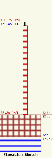
Site Elevation: 36.3 meters (119 ft) |
| Height of Structure: 146.3 meters (480 feet) |
| Overall Height Above Ground: 152.4 meters (500 feet) |
| Overall Height Above Mean Sea Level: 188.7 meters (619 feet) |
| Owner Info | CITY OF CONROE FIRE DEPARTMENT
300 WEST DAVIS
CONROE, TX 77301
(936) 522-3080
kkreger@cityofconroe.org |
| Contact Info | CITY OF CONROE FIRE DEPARTMENT
300 WEST DAVIS
CONROE, TX 77301
(936) 522-3080
kkreger@cityofconroe.org |
