|
|
Antenna Structure Registration 1285964 |
 |
Registration Info | Registration Number: 1285964 |
| File Number: A1099248 |
| FAA Study: 2012-AEA-2634-OE |
| FAA Issue Date: 06/26/2012 |
| Status: Constructed |
| Date Constructed: 07/25/2013 |
| FAA EMI: N |
Structure Info
| Structure Type: GTOWER |
| Structure Coordinates: 39-20-17.6 N 81-29-56.0 W (NAD 83) |
| Structure Coordinates: 39-20-17.3 N 81-29-56.6 W (Converted to NAD 27) |
| Structure Address: 259 Pleasant Valley School Road |
| Structure City: Vienna, WV |
| Structure County: Wood County |
| Painting & Lighting Info |
FAA Chapters: NONE |
Remarks: Removed expiration date from determination. Scenario 1./jjs/case#635066 |
| Elevation Info |
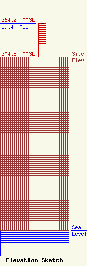
Site Elevation: 304.8 meters (1000 ft) |
| Height of Structure: 59.4 meters (195 feet) |
| Overall Height Above Ground: 59.4 meters (195 feet) |
| Overall Height Above Mean Sea Level: 364.2 meters (1195 feet) |
| Owner Info | Mid Ohio Valley Radio Corp.
2354 Greens Run Rd.
374
St. Marys, WV 26170
(304) 684-3400
TPT@SevenRangesRadio.Com |
| Contact Info | Attorney
733 Fourth St.
Marietta, OH 45750
Tom Taggart
(740) 568-8170
tpt@SevenRangesRadio.com |
